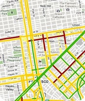
 Shvartzberry sent us a link to an interesting article on Google’s Official Mobile blog about how Google is using the My Location information to aggregate traffic information. Google has been using information it collects from Google Maps users to power their traffic layer which now covers all U.S. highways and arterials where they have data.
Google combines the data they get about your speed and the speed of other phones on the road to get an idea of how traffic is flowing. They combine this data from other phones to get a better idea of traffic conditions. Pretty cool!
This is scary from a privacy standpoint but Google has made every effort to anonymize the data by deleting start and end points. I am still kind of wary about any data aggregation of my location but I guess I can see the benefit. Especially considering the fact that cell carriers already have the ability to do this on their own. I think RIM has the same idea after they purchased Dash which also used their GPS devices internet connection to share live traffic information.
The only downside I have with this is that I almost never use Google Maps while driving. I tried it once in Washington DC and found it almost impossible to hit the next and previous buttons while driving and reading the small screen. The lack of voice prompts and auto routing to the next point make it subpar to even my $100 Mio c310x. I wish Google would finally release their own GPS app with voice prompts and an actual cockpit view.

Amir Saad Not Registered
Posted: September 1, 2009 at 10:28 AM EST
One week ago, I notice here in Houston, TX that highway 6 showed a red mark on it after a heavy storm killed a couple of lights on my way north using that route.
3 days later I noticed that google’s traffic report went beyond Conroe, TX (30 miles north of Houston) and 2 days ago in downtown Houston, I saw more traffic reports on local streets.
I find it really hard to understand the red marks on local streets because they have lights and it’s a matter of how long you’re going to stop in that light vs. if you are ever going to stop on the highway.
@Ronen: Mio 310x doesn’t support traffic reports, using google maps before you hit the road to..roughly…plan your trip before you hit the road is a very smart decision (P.S.: I have a Mio 310x but I migrated to the Navigon 7200T with free traffic report and lane assistance)
Try Gokivo by NIM on your Bold with sound and mute your Mio 310x (if you can), you will be amazed at the short cuts and reroutings you get during rush hour or really bad traffic.
Funny thing is, Google maps doesn’t update their software from the consumers end, but from their end which is very convenient.