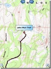
 TopoSports has created some really cool sports apps in the past. Their latest creation is TopoMaps which they call a “wilderness navigation app” offering TopoQuads (topographic maps) covering major spots in the US for biking, hiking, and backcountry camping. The maps are all fully offline and combined with your GPS they offer accurate UGSG maps covering the entire US except for Alaska which is coming soon. These maps cover popular destinations like Yosemite, Yellow Stone, and more.
This app is essentially a handheld GPS app for hikers where there is no cellphone reception for apps like Google Maps to work. It is a bit pricey at $21.99 but it is currently on sale for $14.99 at this link. You can also check out a video of the app in action at this link.
Features include:
- Download topo maps of any quad in US for offline usage.
- The app lets you download topo maps of any quad in US.
- The maps have been re-projected for WGS84 datum and are GPS accurate for all mobile devices.
- There are two ways to download the maps:
- Search for a quad of your choice by specifying the feature or quad name. It is strongly recommended that you provide the state for which you are trying to download the map.
- We also have list of popular quads for you to choose from.
-
Seamless mosaicing of quad
-
If you download adjacent quads, the app automatically switches from one quad to the other when you scroll.
-
Distance/Bearing tool
-
Measure distance and bearing from the center of the map to any point.
-
Create custom way points – You can create custom way points in two ways:
- From your current location.
- Manually selecting a point on the map.
-
POI layer for each quad
-
All the quads come with a list of POIs for that quad.
-
The POI layer can be overlaid on the quad map. The app automatically figures out which POI layer to load.
-
Clicking on a POI would show its geographic name.
-
The POI list is the complete list of geographic names published by GNIS.
-
Search POIs/Way points
-
You can search for created way points/POIs by name.
-
-
Pan/zoom/locate yourself
The software supports standard mapping featurs like pan/zoom to get an overall idea of the region. The maps have been reprojected for WGS84 datum so that they are GPS accurate .If your device has a GPS or you use a bluetooth GPS puck, you can locate yourself at any time.
-
Record GPS tracks
If your device has GPS or you use a bluetooth GPS puck paired with your device, you can record your GPS tracks.
-
View tracks overlay
If you turn on track recording, at any point you can view the map with your tracks overlaid on the map in dark brown color. This would help you figure out with a glance where you have been and what area you haven’t touched at all.
-
Live track animation
If you turn on track recording, you can play your track at any time. The track play shows you a red dot traversing the map. The speed of the red dot is proportional to how fast you go. The red dot goes faster at places where you go faster. You can see your speed at the bottom left corner of the phone screen.
-
Track analytics/stats
The app shows the following stats for each track:
-
– Distance covered
-
– Average speed
-
– Maximum speed
-
– Time taken
-
– Pace (time taken to cover a mile or km)
-
– Calories burned
-
– Vertical ascent/descent
-
Export tracks in GPX format.
– You can export tracks in GPX format to SDCard/device memory.
– GPX tracks can be shared with others or viewed on Google earth.

victor Not Registered
Posted: August 16, 2010 at 12:54 PM EST from my BlackBerry 9700
This could of been a nice giveaway, for those that enjoy hiking 🙂